Santa Monica
LOOKOUT
Traditional Reporting for A Digital Age
Santa Monica |
| Home | Special Reports | Archive | Links | The City | Commerce | About | Contacts | Editor | Send PR |
|
|
NewsLists
|
||
|---|---|---|---|---|
|
By Jorge Casuso March 27, 2024 -- It can arrive within minutes or take hours to reach the coast, but if a tsunami strikes Santa Monica, ocean waves could reach as high as a five-story building. Which doesn't mean those on the top floors of a highrise will be safe, since most buildings are not designed to withstand the impacts from such tsunami waves.
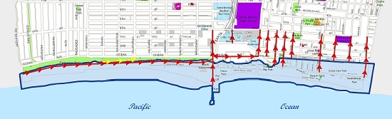
So what can Santa Monicans who live or work along the coast do to survive a disaster that has never struck the city of 93,000? City Emergency Management officials are providing answers, as well as tips and maps, during Tsunami Preparedness week, which ends Easter Sunday. "Most tsunamis are generated by earthquakes or landslides caused by earthquakes, and due to the unique terrain along the Santa Monica coast, residents must be prepared for these catastrophic events," City officials advised this week. "If you are near the coast during a seismic event, a tsunami can be detected by strong ground shaking, a loud ocean roar, or the water receding unusually far and exposing the sea floor." But large earthquakes aren't the only cause of tsunamis -- so are landslides, volcanic activity, certain types of weather and near earth objects, such as asteroids and comets. And the triggering event can take place thousands of miles away. "Even distant events can create fast waves that can travel across the Pacific Ocean and impact California's coastline," emergency officials said. Tsunami waves don't need to rise more than three feet to be menacing, since it's "the force behind the tsunami wave that presents the greatest danger." "The additional force behind the tsunami wave can drive a 1 to 3 foot wave significantly farther inland than a wind-driven wave, creating large inundation zones with potentially life-threatening currents and debris," officials said. "Tsunami waves are usually filled with life-threatening debris which can severely hurt someone, and the column of water does not have the same composition as a wind-driven wave." In the event of a tsunami the City worked with state officials to develop evacuation and communication plans. A map shows a theoretical “inundation zone” that marks the areas that would be affected by a 30-foot surge in the sea level (California Tsunami Hazard Area Map). Such a surge would be blocked north of the pier by the 100-foot-tall Palisades Bluffs, but dozens of single-family homes west of PCH lay within the inundation zone. So do Ocean View Park, the Sea Colony and the twin Santa Monica Shores high-rises west of Main Street south of the pier. The map also shows tsunami evacuation routes that are posted on signs along affected streets. City officials advise those in a tsunami hazard zone to evacuate by foot or bicycle after the shaking stops if they:
Those who live outside of the tsunami hazard zone, should wait for official instructions before evacuating. When a tsunami is detected, warnings will be issued by Wireless Emergency Alert, radio, television, telephone, text message, and door-to-door contact by emergency responders, emergency officials said. Those who register with the City for SMAlerts will receive emergency updates via phone, email or text message to assist with evacuations within the City. |
| copyrightCopyright 1999-2024 surfsantamonica.com. All Rights Reserved. | Disclosures |